Kersa Demographic Surveillance and Health Research Center (KDS-HRC) is located in Kersa district of eastern Hararege, Oromia region, Eastern Ethiopia. It was established in 2007 with the vision of becoming center of excellence in health science research in Ethiopia. It conducts health and demographic surveillance. The major work on the ground are monitoring demographic altering events such as birth, death, and migration; and health related conditions such as pregnancy, immunization, and morbidity. It also conducts verbal autopsy for the deceased to identify causes of death. It is an INDPTH network member site (http://www.indepth-network.org).
KDS-HRC aims at generating up-to-date community based data including vital events; conducting studies addressing national health need; assessing trends of demographic, health and environmental changes; evaluating health intervention activities; enhancing research culture in the teaching and learning process; rendering support on research methods and analysis for students and staff; disseminate research findings to different users; and advocating utilization of research findings to improve the health and other service delivery. More explanation about KDS-HRC please visit www.haramaya.edu.et/research/projects/kds-hrc.
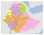
Eastern Hararge
 It one of the 15 Zones of Oromia regional state. It is bordered on the southwest by the Wabe Shebelle River, which separates it from Bale zone; on the west by West Hararge zone the north by Dire Dawa administration; and on the north and east by the Somali Regional state.
Based the 2007 census, the zone has an estimated total population of 2,739,390, of which 6.9% of its population is urban dwellers. The zone has an area of 24,900.21 square kilometers, and a population density of 102.64 people per square kilometer. The health coverage of the zone is 80 %. Forty four percent of the zone is malarious area.
Kersa District:
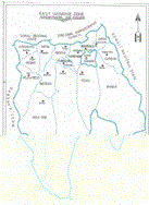
It is one of the 16 districts of Eastern Hararge zone. It is bordered on the south by Bedeno district, on the west by Meta district, on the north by Dire Dawa administrative council, on the northeast by Haramaya district, and on the southeast by Kurfa Chele district. The district capital is Kersa town which is 44 km from west of Harar city; other towns in the district include Lange and Weter.
According to a survey of the land in Kersa (released in 1995/96) showed that 28.5% is arable or cultivable, 2.3% pasture, 6.2% forest, and the remaining 56.3% is considered built-up degraded or otherwise unusable. Khat, fruits and vegetables are important cash crops. Coffee is also an important cash crop; covering 5,000 hectares. Sorghum, maize, barley, white etc are among the food crops cultivated in the district.
Kersa field research center
The Health and Demographic Surveillance System (DSS) runs in 12 representative Kebeles out of the 38 in Kersa districts.
Out of the 12 Kebeles ten are rural and two are urban (Kersa and Weter town); whereas by altitude difference, 2 are highland two are low land the remaining 8 are mid land (Woynadega). All the 12 study Kebeles have road access during the dry season. But it is not very hard to reach to Kebeles during the rainy season also.

Lake Adele on the way to Dire Dawa is adjacent to Adele Key Key. It is one of the beauties of the site.
The way to Weter town, seen straight far

The highland majesty around GolaBelinakebele

All the Kebele administrative offices have land line telephone connection. In addition, in towns some dwellers have landline telephone connection but a significant numbers of residents in the both urban and rural study Kebeles have mobile telephone. The three towns have 24 hour electricity supply. In addition, few areas in some rural kebeles, there is electricity supply. Residents in the study kebeles get water supply from tap water, protected springs, unprotected springs, protected and unprotected well and ponds.
There are 3 health centers and 10 health posts in the 12 kebeles of the study site. All the kebeles have 2-3 health extension workers assigned to work on the 16 health extension packages. There are 18 elementary, 2 secondary, 1 preparatory, and 2 religious schools in the study Kebeles. There are also 134 mosques, 8 churches and 6 farmers training stations.
Student’s singing squad on typical school day. Tolla Kebele elementary school.
The inhabitants of the study site make their living principally on farming. But small trade, government employment and daily work are also means of living. Cereals like wheat, barley, and vegetables like onion and garlic are the dominant crops produced in the highland areas. Sorghum, maize, potatoes are dominant crops in the midland and low land areas. Khat is the dominant cash crop production in most of the places.
Farming is seasonal in the study Kebeles. They make production during the rainy season. But in one of the Kebeles (HandhuraKossum), irrigation is a common practice. Residents of this kebele produce three times a year, majorly for market.

Sorghum, the dominant crop for food production in many of the mid land and low land areas of the study site

Wheat, barely, the dominant crop for food production around Tolla and GolaBelina Kebele

Vegetates are also common production around highland areas, here the farmer working in garlic farm.
Khat is the main crop produced for cash in many of the mid-land and low land areas of the study site.
